
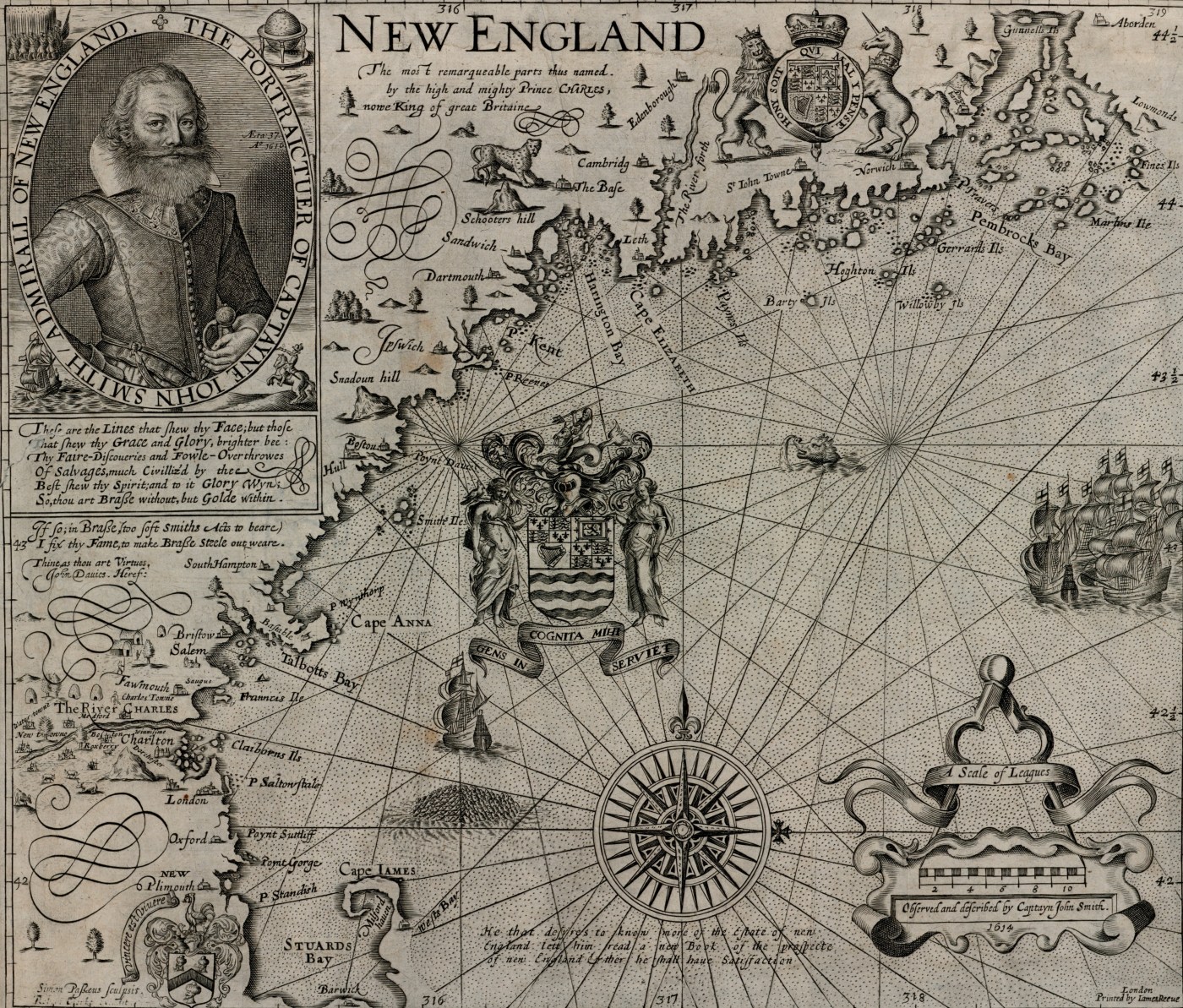
The New England towns that dotted Captain John Smith’s 1616 map (above) didn’t really exist, but a sixteen-year-old English prince named Charles had taken the liberty of replacing Smith’s indigenous place names with English ones, most of which did not survive the era of Puritan migration. As to the future site of Hampton, located on the mainland just south of “Smiths Iles,” neither the young prince nor Smith had paid much attention—its place on the map was nameless and nearly hidden by Smith’s outsized portrait.
A decade later, William Alexander, the future viscount of Canada, divided New England north of Cape Cod into twenty feudal manors, each with its own named governor. Alexander’s plan met the same fate as Charles’s imaginary towns, but if it had been enacted as envisioned, a church historian named Sir Henry Spelman would have governed the still-unnamed area that one day would be called Hampton.

Soon enough, place names that modern Hamptonians would recognize began to appear on maps. William Wood’s 1634 map identifies “Strabery Banke” and “the boreshead,” and Reverend William Hubbard’s 1677 map, drawn to illustrate his account of King Philip’s War, marks the town of “Hamton.” Then in 1689, a decade after King Charles II had ordered the separation of New Hampshire from Puritan Massachusetts (much like the Puritans had ordered the separation of his father’s head from its body 40 years earlier), the correctly spelled town of Hampton, with its coastal promontories of Great Boar’s Head and Little Boar’s Head, appeared on an English map.

1737-1741 Mitchell map
The establishment of the Province of New Hampshire renewed the question of the true location of the Massachusetts colony’s northern boundary—did it extend three miles north of the northernmost point of the Merrimack River as claimed by Massachusetts, or was it a straight westerly line three miles north of the river’s mouth as claimed by New Hampshire? The competing claims launched a dispute that would drag on for years, with both sides asserting taxing authority over the inhabitants of the disputed zones. King George II of Britain would have the final say, his decision guided by the map prepared by George Mitchell, a surveyor who had spent the previous five years mapping stands of mast trees in Nova Scotia. The town of Hampton and its harbor appear on his 1741 map, which plots the so-called Mitchell Line. Ultimately, the king chose a line similar to the boundary as it exists today.

1761 Blanchard-Langdon map
Colonel Joseph Blanchard of Dunstable, New Hampshire served in the New Hampshire militia and fought in the French and Indian War. Assisted by Samuel Langdon, a regimental chaplain from Portsmouth, New Hampshire, he surveyed “An accurate map of His Majesty’s province of New-Hampshire in New England…which exhibits the theatre of this war in that part of the world.” Hampton, Great Boar’s Head, and “Hampton R. & Marshes” appear on this map, published three years after Blanchard’s death in 1758.

1806 Leavitt map
In 1803 and 1805 the New Hampshire legislature directed that a state map be compiled, and to that end it required all New Hampshire towns to make plans of their territories. The plans were to show all principal roads, water features, mountains, hills, and the names of adjoining towns, and were to be transmitted to the office of Secretary of State Philip Carrigain by June 10, 1806. The resulting state map, published in 1816, features a pictorial vignette of Boar’s Head.
To produce Hampton’s contribution to the project, the town hired Thomas Leavitt of Hampton Falls. A selectmen’s record for 1806 shows that the town paid $64.85 for “surveying the town.” To engrave the map, Leavitt recruited his friend James Akin, an artist and political cartoonist then residing in Newburyport, Massachusetts. The selectmen evidently had not approved the expense beforehand, as the town voted “not to allow Thomas Leavitt Esq. [his] account for engraving the plan of the town of Hampton.” Leavitt’s map is the first to include a detailed portrayal of Hampton’s built environment: churches, schools, businesses, and the names and locations of property owners.

1830 Hampton map
This rustic, color-coded map by an unknown maker was found in the North Hampton Library and donated to the Hampton Historical Society in 2008. The linen backing suggests that it may have been used as a wall map. Besides depicting the principal buildings and the names and locations of property owners, it identifies two roads by their names then in use, Sandy Lane (Winnacunnet Road) and Nook Lane (the eastern end of High Street).

1841 Marston-Dow map
At the 1837 annual meeting the town voted to hire former school teacher Josiah Marston to survey and draw a plan of the roads in town. Edmund W. Toppan assisted Marston by keeping the minutes of the survey. In 1840 the town authorized the selectmen to make any necessary corrections to the map and print 250 copies for the use of the legal voters. Former Hampton Academy principal Joseph Dow added the town’s boundaries and rivers, and, notably, the track of the Eastern Railroad that now cut through town. Like the 1806 and c. 1830 maps, the built environment was included, as was a commentary on the town’s history, the output of its fishing, farming, and salt industries, and a census of human and livestock populations. The Marston-Dow map is the only one known to have been proposed and carried out by the town itself.

1857 Rockingham County map
The 1857 county map, published as a large color wall chart, was compiled from surveys by John Chace, Jr., a prolific surveyor of county maps in New Hampshire, Vermont, and Maine. Property owners and structures are named, and pictorial vignettes of Hampton Academy and the residences of Aaron Coffin, Esq. and Dr. William T. Merrill are prominent among the illustrations that line the map’s border.
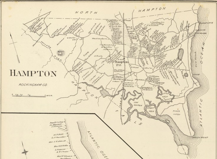
1892 Town and City Atlas
From his publishing offices in Boston, Massachusetts, historian Duane Hamilton Hurd produced dozens of works on the histories of New York and New England, including the illustrated 1882 History of Rockingham and Strafford Counties. Maps of Hampton and Hampton Beach appear in Hurd’s 1892 Town and City Atlas of the State of New Hampshire, which is the last privately published map of this type to mark Hampton residents’ names and property locations.
1892 Dow’s early settlers map
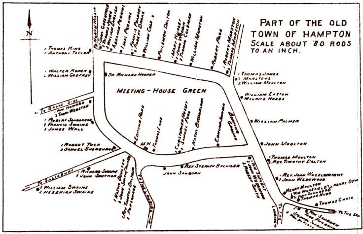
This illustration, included in Joseph Dow’s History of Hampton, identifies the locations of the church and homesteads of the early settlers at the original center of town, the so-called “Ring” that encompassed the area now bounded by Park Avenue, Winnacunnet Road, and Lafayette Road.

20th century Sanborn insurance maps
In 1867, Daniel Alfred Sanborn published his first fire insurance map for the city of Boston, Massachusetts. Realizing the lucrative market for this kind of map, Sanborn built his company into the country’s largest insurance mapper. The company’s near monopoly and premium prices spurred competitors to develop cheaper methods of assessing fire risks, and by the mid-20th century the Sanborn Map Company had diversified into more profitable mapping activities. From 1904 to 1942, Sanborn mapped the commercial, industrial, and adjacent residential sections of Hampton and Hampton Beach.
Guides to the past
More than just tools that point the way from here to there, maps reflect the interests of their audiences at the time they are produced. Early maps like those of Captain John Smith and William Wood helped would-be colonists see into the unknown by depicting the natural resources, wildlife, and native populations of what was then a vast wilderness. Maps like Colonel Blanchard’s, made during the wars of the 18th century, marked military forts and pointed out the trails where Indians were known to carry off their captives. Maps made during the relatively peaceful decades following the establishment of the United States paid marked attention to domestic matters—property owners are identified by name and buildings are drawn as they actually appear. Leisure activities, too, are often illustrated, as on the 1806 Leavitt map, which depicts gunners hunting on Boar’s Head while their horse and carriage await. From the 17th century to the 20th, the town of Hampton appeared on state, county, and town maps that were the product of both public and commercial interests. Today these maps serve as valuable guides to the past for historians, genealogists, and anyone interested in the history, growth, and urbanization of the town and its beach.
Originally published in the Hampton Union on July 5, 2019.
Hampton History Matters is devoted to the history of Hampton and Hampton Beach, New Hampshire. Hampton History Matters Volumes I & II are available at amazon.com.

Leave a comment